


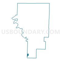
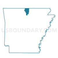
Voting District 11-7, Baxter County, Arkansas
About
Outline

Summary
| Unique Area Identifier | 525891 |
| Name | Voting District 11-7 |
| County | Baxter County |
| State | Arkansas |
| Area (square miles) | 1.17 |
| Land Area (square miles) | 1.16 |
| Water Area (square miles) | 0.01 |
| % of Land Area | 99.44 |
| % of Water Area | 0.56 |
| Latitude of the Internal Point | 36.00429120 |
| Longtitude of the Internal Point | -92.40829390 |
Maps

Graphs
Select a template below for downloading or customizing gragh for Voting District 11-7, Baxter County, Arkansas


Neighbors
Neighoring Voting District (by Name) Neighboring Voting District on the Map
- Voting District 11-6, Baxter County, AR
- Long Creek Voting District, Searcy County, AR
- Rock Creek Voting District, Searcy County, AR
Top 10 Neighboring County Subdivision (by Population) Neighboring County Subdivision on the Map
- Rock Creek township, Searcy County, AR (547)
- Long Creek township, Searcy County, AR (474)
- Big Flat township, Baxter County, AR (198)